
Greece Is presents "Peloponnese Trails," a walkable journey through nature, history, and myth via a vast network of hiking routes that connects the Isthmus of Corinth with the Temple of Apollo Epicurius and Cape Maleas.
By Nina Maria Paschalidou | May 21st, 2025
“The idea is simple. When someone lands at Athens International Airport, they can take the suburban railway and get off at Corinth, Kiato, or Xylokastro. And that’s where the trails begin. If you want to hike for a month, you can – with breaks every five hours to rest, eat a tomato, an olive, a sweet. All you need is your feet and a good heart,” says Ioannis Lagos, president of the Social Cooperative Enterprises of the Peloponnese. His dream is now becoming reality.

© Source: Anavasi Editions
© Source: Anavasi Editions
Designed as a holistic model for thematic tourism, Peloponnese Trails integrates storytelling, local gastronomy, education and training for tourism professionals, and regional branding – all with the goal of revitalizing the countryside and strengthening local economies.
“We are talking about a network of 1,730 kilometers of trails connecting the entire Peloponnese. The blueprint for this grand network began in 2015 with the creation of the Menalon Trail in Arcadia’s mountainous Gortynia. Spanning 75 kilometers and connecting nine traditional villages, the Menalon Trail was the first hiking route in Greece to earn European certification. At its inauguration, I first spoke of this greater vision – uniting the Peloponnese’s trails, following the paths of early travelers who walked from one archaeological site to another, documenting everything. The region saw the positive impact of the Menalon Trail and decided to expand the initiative.”
Length: 67.2 km
Symbol: The Greek letter “k” for Korinthos
 
Key points: Isthmus, Isthmia, Kyra’s Spring, Kechries, Xylokeriza, Agios Ioannis, Agionori, Stefani, Mycenae
Highlights: Isthmia Archaeological Museum, Corinth Canal Bridge, Kechries Beach, Agionori Castle, Stefanion Observatory, Citrus Institute of Corinthia
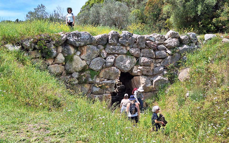 Argolis Trail, section "Argoliko–Epidaurus." The trail passes by the two best-preserved Mycenaean bridges along the Mycenaean Road that once connected Mycenae with the Asclepieion of Epidaurus.
Argolis Trail, section "Argoliko–Epidaurus." The trail passes by the two best-preserved Mycenaean bridges along the Mycenaean Road that once connected Mycenae with the Asclepieion of Epidaurus.
Argolis Trail, section "Argoliko–Epidaurus." The trail passes by the two best-preserved Mycenaean bridges along the Mycenaean Road that once connected Mycenae with the Asclepieion of Epidaurus.
“This is an innovative project,” says Deputy Regional Governor of Tourism, Thanos Michelongonas. “One of its core elements is outdoor tourism. We reviewed the existing infrastructure and created a network spanning 1,700 km, under the management of O.F.Y.P.E.K.A. (the Greek Natural Environment and Climate Change Agency). We are also restoring a further 2,000 km through different programs.”
“Execution relies on local communities and social solidarity economy entities. They are our partners, the caretakers of these trails,” adds Michelongonas. Lagos agrees: “Local engagement is the only way. We collaborated with social cooperatives, hiking clubs, and nonprofits. That’s how we were able to create the first 1,000 km in one year. Though work temporarily paused, it later resumed with the involvement of O.F.Y.P.E.K.A.”
 
Each team is responsible for its own section, working with local shepherds when needed. Much of the trail network revives forgotten mule paths, which fell out of use in the 1970s with the introduction of agricultural roads. Of the 1,700 km, 700 are old paths and 1,000 are new.
Trail work includes marking key points and creating rest areas, all of which are carried out with care for the surrounding landscape. The Region has partnered with the Development Agency Parnon S.A., which oversees the project. According to director Panagiotis Mouzakiotis, the scope includes clearing, restoring access, signage, digital mapping, and promotional actions. Completion is expected by the end of 2025.
Length: 176.3 km
Symbol: The winged sandal of Hermes Routes:
 
Branch A: Derveni, Zaholi, Sarantapicho, Tarsos, Panagia Vrachon, Feneos, Madaro, Tourkovrysi, Lake Doxa, Kerkena Spring, Panorama, Villia, Goura
Branch B: Xylokastro, Manga, Flampouritsa, Hermes Cave, Dasios Lake, Gelini, Karya, Skafidia, Goura
Points of Interest: Ancient Sicyon, Jewish Cave, Byzantine monastery of Panagia Lechovi, Kefalari village
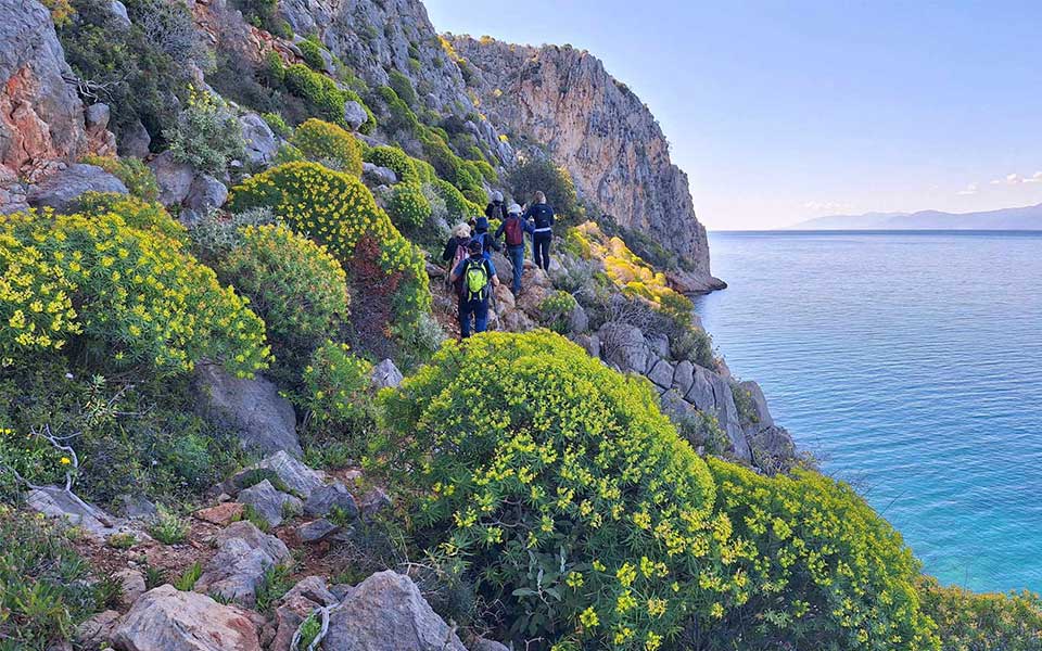 Argolis Trail, Nafplio–Karathona–Asini.
 © Dimitris Kindis
Argolis Trail, Nafplio–Karathona–Asini.© Dimitris Kindis
Themed, Sustainable Tourism
Regional Governor Dimitris Ptochos calls it a major step toward thematic and sustainable tourism. “Peloponnese Trails, the largest hiking network in Greece, reconnects visitors with the region’s authenticity. Designed with respect for the landscape, it fosters collaboration among communities, businesses, institutions, and volunteers. It is a model of gentle, sustainable development. The Peloponnese is the gateway to the most thrilling hiking experience in the Mediterranean.”
Each trail is uniquely named after local history or mythology.
 
Hermes + Hercules Trails form a unified network covering most of Corinthia and Argolida, centered on the protected wetland of Lake Stymphalia. Travelers will see springs, stone bridges, watermills, wells, caves, oak and fir forests, panoramic views of the Gulfs of Corinth and Argolis, colorful plains, and dramatic mountain peaks. It’s a deep dive into history through archaeological sites and religious monuments.
Length: 203.2 km
Symbol: The letter “H” for Heracles
 
Branch A: Kiato, Vasiliko, Nemea, Lake Stymphalia, Feneos, Goura, Mesino, Feneos Sinkholes
Branch B: Nafplio, Midea, Mycenae, Dervenakia, Ancient Nemea, Feneos Sinkholes, Mati, Gouves, Komi, Dara, Kmenitsa, Nymphasia
Points of Interest: Ancient Nemea, Ancient Phlious, Nafplio’s Old Town, Mycenaean Tombs, Temple of Zeus
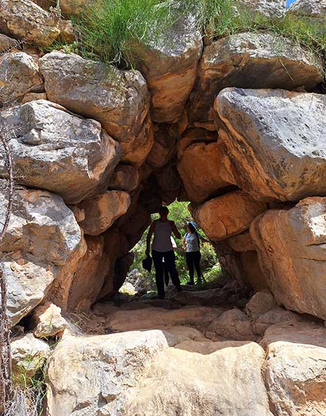 Argolis Trail, section "Argoliko-Epidaurus." The trail passes by the two best-preserved Mycenaean bridges along the Mycenaean Road that connected Mycenae to the Asclepieion of Epidaurus.
Argolis Trail, section "Argoliko-Epidaurus." The trail passes by the two best-preserved Mycenaean bridges along the Mycenaean Road that connected Mycenae to the Asclepieion of Epidaurus.
Argolis Trail, section "Argoliko-Epidaurus." The trail passes by the two best-preserved Mycenaean bridges along the Mycenaean Road that connected Mycenae to the Asclepieion of Epidaurus.
 Argolis Trail, Nafplio–Karathona–Asini.
 © Dimitris Kindis
Argolis Trail, Nafplio–Karathona–Asini.© Dimitris Kindis
Limestone Cliffs and Fir Forests
The Menalon Trail extends through the region of Western Mainalo, traversing the eastern sections of the Gortynian Mountains and the Lousios Gorge. Though mountainous throughout, the terrain is generally gentle except in the Lousios Gorge, where tectonic faults and erosion have shaped massive limestone cliffs. While the whole of Western Mainalo and the Valtessiniko zone are blanketed in fir forests, the mountains above Lagkadia remain bare. The landscape of uniformly sloped limestone sides is broken by large, hollow clearings known as dolines. The Menalon Trail circles one of the mountain’s largest dolines, the Vlachika plateau, with a surface area of around 200 acres. The peri-Menalon areas through which the trail winds showcase a wide variety of landscapes, shaped by geological upheaval and centuries of human presence.
The Menalon Trail connects with the Pan Trail. According to myth, the misshapen god Pan fell in love with the nymph Syrinx and chased her from Mount Mainalo to the banks of the Ladonas River. This mythological path forms the basis of the trail’s route. The two trails are also linked to the Arcadia Trail, which forms a large hiking loop around Mount Lykaion. The route begins and ends in Karytaina. In addition to the main route, there are numerous offshoots that lead to nearby villages or destinations such as the archaeological site of Lykaion or the Temple of Apollo Epicurius. Another branch connects Leontari with Dyrrachio and heads toward Georgitsi in Mount Taygetus, completing the hiking link between Mainalo, Lykaion, and Taygetus.
Length: 62.4 km Symbol: Pan’s flute Connects with Menalon Trail
Key Points: Water Power Museum, Paliohori Dimitsanas, Zatouna, Rafti, Paloumba, Loutra Iraias, Pyri, Kapelitsa, Tripotamia, Erymanthos Bridge, toward Ancient Olympia
 
Points of Interest: Aimyalon Monastery, stone bridges on the Lousios River, Ladoas River, Heraia Baths
 Argolis Trail, Nafplio–Karathona–Asini.
 © Dimitris Kindis
Argolis Trail, Nafplio–Karathona–Asini.© Dimitris Kindis
From Astros to the Temple of Apollo Epicurius
In Eastern and coastal Arcadia, the Parnon Trail unfolds as a circular hiking route that traverses the municipalities of Northern and Southern Kynouria. The route connects Astros with Leonidio, both from the seaside (Astros – Tyros – Sapounakaiika – Leonidio) and through the mountains (Astros – Agios Ioannis – Platanos – Sitaina – Kastanitsa – Prastos – Agios Vasileios – Kosmas – Leonidio). Extensions reach Ano Doliana to the north and extend from Kosmas to Geraki to the south.
The Messinia Trail connects to the Arcadia Trail and consists of two branches. The eastern branch starts at Aghia Theodora, links with the Temple of Apollo Epicurius, crosses the entire regional unit of Messenia, and heads south to Pylos. The western branch begins in Kalamata, passes through the imposing Mount Taygetus, and ends at the fortified town of Mystras. Along the way, hikers can visit landmarks of special significance such as the Temple of Apollo Epicurius, the Kolokotronis Monument, the Castle of Ancient Messene, the archaeological site of Ancient Messene, and the Taygetus ridgeline with its alpine landscape.
 
This is also the area with the richest evidence of olive cultivation in Greece since ancient times. This is a landscape that seamlessly blends mythology and reality: home to the legendary King Nestor and his realm, the land was marked by the three Messenian Wars, the region’s incorporation into the Achaean League, the Roman era, and later invasions by various tribes. These events also shaped the history of the many coastal settlements – such as Kalamata, Koroni, Methoni, Navarino, and Arcadia – that evolved into thriving centers that continue to define the region’s character.
Length: 111.9 km
Symbol: Lambda (L) for Lacedaemon (Sparta)
 
Branch A: Mystras, Sparta, Zagana, Chrysafa, Goritsa, Agrianoi, Polydroso
Branch B: Polydroso, Vamvakou, Karyes, Ano Doliana
Points of Interest: Kosmas, the villages of Zarafona and Tzitzina, the historic city of Sparta, Mystras, the wildlife refuge, Vamvakou, and Varvitsa.
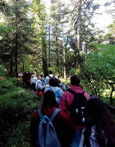 Hike by students of the Dimitsana Primary School.
Hike by students of the Dimitsana Primary School.
Hike by students of the Dimitsana Primary School.
 Hike on the Elati–Vytina section of the Menalon Trail by students of the Dimitsana Primary School.
Hike on the Elati–Vytina section of the Menalon Trail by students of the Dimitsana Primary School.
Hike on the Elati–Vytina section of the Menalon Trail by students of the Dimitsana Primary School.
In Laconia, the flagship route is the Sparta Trail, which links the fortified town of Mystras to the city of Sparta. Perched dramatically on the slopes of Mount Taygetus, Mystras is a UNESCO World Heritage Site and one of Greece’s most evocative medieval ruins. Within its proud stone walls lie the remnants of four abandoned settlements, including exquisite post-Byzantine churches, crumbling mansions, and the once-glorious Palaiologos palaces. Sparta lies in a valley between the Parnon and Taygetus mountain ranges, near the right bank of the Eurotas River, and provides access to key cultural landmarks such as the Tomb of Leonidas, the Archaeological Museum, the Museum of the Olive and Greek Olive Oil, the Kourmantarios Art Gallery, the archaeological site of the ancient city with its Roman theater, and some of the most significant sanctuaries of antiquity.
From there, the trail continues through the villages of Laconian Parnon, each with its own unique beauty and history.
A Gateway to the Medieval Past
 
The Monemvasia–Maleas Trail begins at one of Greece’s most iconic destinations: the famed castle town of Monemvasia. Perched on a rock jutting into the sea, the fortified city feels like a gateway into another era, with its preserved Byzantine churches, stone mansions, and winding alleys. One of the trail’s highlights is the route to Aghia Sofia, a clifftop chapel with panoramic views stretching all the way to the mountains of Crete on clear days. From Monemvasia, the trail guides trekkers Cape Maleas, the second southernmost point of mainland Greece after Cape Tainaron. From there, one can wander through fishing villages, the Cape Maleas Geopark with its fossilized forest and the Kastania Cave in Neapoli, the Stroggili Lagoon, and the Geras Wetland.
A Safe Journey
“Our goal is to expand beyond our own region,” concludes Ioannis Lagos. “We want to create a trail connecting Olympia to Epidaurus. Although Olympia lies in a different administrative region, we are already in discussions with the Municipality of Olympia to extend the Pan Trail and reach Epidaurus.”
“Equally important is the digital mapping of the trail network,” adds Lagos, “which will allow hikers to plan their routes and will also enable us to track their location at all times ensuring safety throughout their journey.”


 Greek (GR) ·
  English (US) ·